| We welcome visitors here every day. Many come to walk in the valley, or across to Staveley or Kentmere, or over Gatescarth Pass to Haweswater, or up on the high fells. Please keep to the footpaths in the lower pastures. Remember that dogs must always be kept under close control even where there is the right to roam; they disturb ground-nesting birds as well as lambs and pregnant sheep, and they threaten cows with calves. | 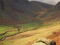 |
Longsleddale is on OS Landranger 1:50,000 sheet 90. Walkers will need OS Explorer 1:25,000 sheet OL7 (north). For Haweswater or Mosedale Cottage use OS Explorer 1:25,000 sheet OL5 (south). CRoW open access land can be seen online:- Search right-to-roam maps.
|
 |
To reach Longsleddale by car, turn north-west off the A6 4 miles north of Kendal or 13 miles south of Shap.
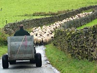
The road in the valley is single track, some four miles long and is not a through route.
It is not suitable for coaches, caravans or boats. Around any corner, drivers and cyclists
might meet walkers, sheep or vehicles. Please keep off the verges and use the passing places.
All the wider parts of the road are passing places, not to be used for parking: cars may be parked at the
community hall or beside the track at Sadgill.
Please be patient, the valley is a working environment, and be prepared to reverse your car,
in particular for farm vehicles with trailers. |
|
 |
At the centre of the valley is the church, which is open during the day, and the community hall;
donations for parking would be very welcome. Here there are picnic tables and well-kept toilets,
and a cards-only phonebox. There is no mobile reception in the valley. The nearest public transport is in Kendal, Burneside or Staveley, and the occasional bus in Kentmere.
|
|
 Longsleddale Home Page
|